Tigernix Logo

Connect with our journey, to learn about the 15+ years of our expertise. Established in 2006, Tigernix clutched innovation, dedication and expertise to serve you with unsevered trust and integrity.

Working hours

Monday - Friday:
8.30 - 17:00 Hours

GIS Integration And Governmental Responsibilities

Share on facebook
Share on twitter
Share on linkedin

Geographic information systems or GIS are computer and software tools that capture, store, analyse and display data that are in some way referenced to locations on the earth. GIS can use any type of data that includes location. The location can be in any of the different forms like latitude, longitude, address, or ZIP code.

GIS is an emerging technology that helps users understand spatial patterns, relationships, and geographic context. GIS technology, therefore, is a critical part of spatial data infrastructure. Industries and governmental bodies utilise GIS tools to achieve excellence for different purposes.

How Does GIS Involve In The Fulfilment Of Governmental Responsibilities?

GIS has been the spark plug for the digital transformation of different government bodies such as townships, cities and countries. Geospatial data analysis enables the efficient accomplishment of many essential management tasks of their highly complex operating models. Mobile capabilities, the use of public data and cloud-based technologies, are empowering new modes of operation, which create powerful insights for government decision making and enhance data-driven processes. Here are 10 key involvements of GIS in the management of governmental programmes and evaluation of government policy outcomes.
Crime Analysis
Crime analysts use GIS to identify crime trends and patterns and help police agencies identify problems, allocate resources, and solve or predict crimes. GIS tools enable the Implementation of various policy methodologies for crime reduction. An agency-specific GIS database is able to offer administrators an opportunity to analyse how policies implemented on different aspects affect operations. The same principle pertains to the modelling and testing of crime theories.
Emergency Management
Government officials use GIS in emergency management because GIS enables efficient coordination of the efforts of various teams and resources. Emergency managers are expected to handle natural disaster challenges using the Comprehensive Emergency Management (CEM) approach which includes the four phases of mitigation, preparedness, response, and recovery. The GIS technology eases each of these phases with its robust modelling capabilities, efficient data collection and analytical tools and more possibilities.
Financial Services

The banking and financial sector uses GIS as a multi-layered source of information about current economic conditions. All kinds of government agencies, investors and economic development professionals, use GIS to extract valuable financial information that leads to the right decisions that might be missed if traditional methods were used instead. GIS tools assist to maintain the highest efficiency and effectiveness of sales and marketing, regulatory compliance, business continuity planning and service location and site evaluation.

Homeland Security
GIS tools can be utilised by government agencies and defence contractors to develop an enterprise system that assists in identifying, tracking and securing the locations of important people, infrastructure and other assets. The system is able to offer powerful decision-making tools in several locations to visualise threat or activity locations and coordinate response and recovery. GIS applications like orthorectified topographic base maps, remote sensing data, and vector layers are now the basis for evaluating security risks and modelling emergency plans.
Health and Human Services
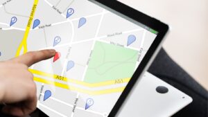
GIS releases smart health and human services solutions from area planning and property assessment to emergency services. The improvement of health outcomes and access to health care and building healthier communities require an advanced approach as understanding health and human service issues have become more complex and expensive than ever before. Public health service agencies trust the GIS technology to address the opioid crisis, homelessness, food insecurity, health risks, environmental issues, racial inequities, and more.
Service Routing

The use of geospatial data enables efficient routing of trash pickup, leaf collection, snow ploughing, mail delivery, etc and therefore reduces costs. GIS has the possibility to allow fast route changes, real-time adjustments, and manage timely deliveries, arrival times and other transportation. A customised GIS would even possess more possibilities like the provision of fuel station information and weather information, accurate measurement of road mileage, and adaptation of routes to optimise travel.

Water Utility Management
The GIS technology successfully maps almost all the data related to water, wastewater and stormwater utilities initiating an ideal approach to intelligent water utility management. GIS tools help to identify consumption patterns and risks, locate and maintain assets, detect defects, assess quality, coordinate resources, plan and prioritise development and repair projects, etc. which will maximise the profits of the authorities while maximising the customer satisfaction too.
Airport Operations
The GIS technology is at the heart of the aviation industry with its ability to manage increasingly complex airport operational tasks with airspace maps, flight patterns and other data required by aviation planners, air-traffic controllers and pilots. Asset management, safety and security, regulatory compliance, passenger experience, and all other aspects can be optimised through accurate, efficient and reliable GIS tools. Since they offer distributed and multi-tasking processing, various aviation activities would be able to be coordinated at the same time.
Tourism
The application of GIS in tourism lifts the quality of tourist experience to an unbelievable level through efficient management and exchange of information. GIS not only gives information on tourist attractions, but it is also an accurate and updated database of many features like geographical conditions, transportation, parking, fuel stations, accommodation, restaurants, shops, specialty businesses, entertainment venues, ethnic groups of the population and more that benefit visitors, residents and tourism professionals.
Telecommunications
Telecommunications, as one of the fastest emerging GIS markets, largely rely on its real-time information for strategic planning which is the primary driver for the increased demand for GIS in the field. The broad telecommunications networks generate large quantities of geographically dispersed asset data that can be ideally managed with GIS tools. GIS mapping allows service providers to enhance network planning, deployment, maintenance, operations, sales and marketing and more.

Importance of GIS Integration and Government Responsibilities

Improved decision making, cost reduction, boosted efficiency, improved communication, and easy recordkeeping are among the key benefits of Cerexio GIS technology to local governments. With GIS, governors combine various types of data to generate understanding, operationalise solutions, communicate powerful insights, and engage stakeholders and the public. Using GIS to incorporate location intelligence into excellent decision making enables powerful insights into critical issues the nation faces and allows best practices in policy making.
© Tigernix Pty Ltd, 2024. All Rights Reserved.
Home Privacy  |  Disclaimer  |  FAQ  |  Contact