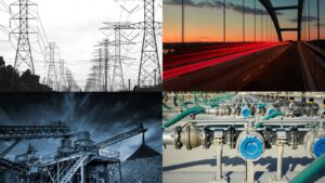
Water is one of the main elements of feeding the sustenance of life on earth. However, even though water dominates a significant proportion of the earth, the amount of freshwater available to produce potable water is minimal. The limited amount of freshwater sources in the face of surging population rates is a dire sensitive challenge that everyone should face in the coming future. This is why water utility service enablers completely depend on digital technology to conserve water and reduce non-revenue water levels singularly.
Amongst these technological capabilities, satellite technology is considered a newly-fangled yet highly disruptive technology that facilitates the water service enablers in Australia. This article investigates the use of satellite technologies by water utility service enablers in Australia to overcome challenges and resourcefully streamline water reticulation systems from water sources to the consumer’s tap.
Why Water Management is Crucial in Australia
According to aph.gov.au, the annual rainfall in Australia is highly variable, and so is the annual water use in Australia. However, 40% of the yearly rainfall is less than 300mm, and due to the failure of the winter and autumn seasons, some areas of Australia are highly impacted by fewer rain frequencies. Therefore, various sectors of the Australian government are frequently challenged in water harvesting, purification, storage and reticulation.
Water management is no longer a responsibility that can survive with traditional technology; with every passing minute, it becomes more data-sensitive, so most Australian state and governmental water service providers rely more on digital technologies. However, there are still water service enablers who are reluctant in employing industry 4.0-defined technologies. Therefore, they are still on the journey of utilising new-age technologies. Many such establishments fail to understand the importance of satellite technology in streamlining the national water operations under the impression that this technology is still in the premature stages of being deployed, and huge investments must be made to employ satellite-based analytical systems.
Satellite Technologies that Facilitate The Water Sector
Landsat satellites and commercial satellites like SPOt satellites are used by many water utility services enabled after the advent of SAT (Synthetic Aperture Radar) technologies. Satellite technologies with remote sensing analytical capabilities and high-resolution polarisation have enormously contributed to the water utility sector. It optimised water quality mapping capabilities, natural hazard management to conserve the health of the water infrastructure, environmental monitoring and more.
Low-orbit satellites are used by the data scientist who serves the water future to determine decisive parameters for water specialists, like:
- bottom pressure and on land
- snow and ice depths
- soil moisture,
- the sum of groundwater,
- surface mass,
- surface water,
- total water storage, and other derived variables.
Benefits of using Satellite Technologies by Water Utility Service Providers
- Administering the water quality of potable water systems by integrated satellite data systems to IoT-powered smart sensors
- Gain a comprehensive perspective on how to drive value while streamlining into policy instruments and suffix policy requirements when connecting EO technologies to land-based data silos
- Have the upper hand in addressing the current and future detriments f water systems
- Improve the organisation’s resilience in delivering remarkable values to levels of service and conserving natural resources along the journey
- Mapping the soil loss and erosion to understand the rate of water risks on land
- Monitoring and maintaining hard-to-reach water infrastructure of water and wastewater systems to capitalise on their full remaining life cycles
- Optimise the distribution, management and regulation of water bodies and systems
- Predicting flood events to protect the catchment area and reticulation systems
- Presupposing the natural hazards (landslides, pollution, harmful algal blooms, industrial waste discharges, bushfires and more) that can tarnish the quality of freshwater or the health of water infrastructures