Geographic Information Systems, or GIS, are revolutionising how we understand and interact with the world around us. This is why there is a rising demand for this particular technology around the world. From urban planning to environmental protection, GIS is used across countless industries, especially in Australia. But what exactly can GIS do?
In this article, we dive into the five core functions of GIS, exploring how it captures data, unlocks insights, and empowers better decision-making.
Exploring GIS Technology
- Before GIS technology became popular, only a few experts could manually analyse geographic data to explain events, plan solutions, and predict future outcomes.
- But the time has changed! Nowadays, computer-based GIS apps make these tasks much easier and faster. These apps combine maps with data, perform various analyses, and create advanced maps, reports, and visualisations.
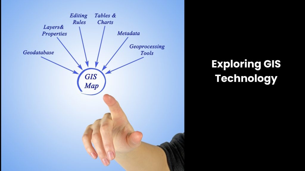
- What are the strengths of GIS? You know, key GIS functions include data input through automated and manual digitisation, data editing and management using database systems, and generating analyses, reports, and visualisations via integrated options.
- Its mechanism is somewhat complex. When users input geographic data, GIS categorises and links the records based on geographic references, storing them in databases. These references can be explicit, like latitude and longitude, or implicit, like a street address or zip code.
- GIS usually geocodes implicit references to create explicit ones, making it easier for mapping and analysis. For example, a school’s location (latitude and longitude) is spatial data, while its name and type are attribute data.
- However, the capacity of the latter does not end there! GIS allows users to perform ‘why’ and ‘what if’ queries when embedded with supportive technologies such as Data Analytics, Predictive and Preventive Maintenance, etc. This way, it paves the way to analysing the relationships between spatial and attribute data. This process quickly generates globes, maps, charts, or reports, helping users visualise, understand, and share their results easily.
The Five Functions of GIS

Data Capture and Management
This is undoubtedly the main function of GIS.
The latter acts as a central hub for all your location-based data, including street addresses, property boundaries, environmental data, and social statistics. You can capture this data from various sources using GIS, ensuring it remains accurate, consistent, and up-to-date.
Plus, it provides tools to organise, store, and manage this data efficiently. Data capture involves both automated and manual digitisation, converting information from maps, surveys, and other formats into digital form. You can use GPS devices, satellite imagery, and field surveys to collect precise geographic coordinates.
In the next advanced step, GIS categorises this data, linking records based on geographic references like latitude, longitude, street addresses, or zip codes. This process involves geocoding, converting implicit references into explicit ones for better analysis and visualisation.
Once you capture the data, GIS allows you to edit, update, and maintain it through a robust database management system (DBMS). You can perform queries, analyse spatial relationships, and generate reports, maps, and other visualisations.
Data Analysis and Modelling
In this stage, GIS goes beyond simply storing data. Why would we say that?
It lets you analyse it and extract meaningful insights. With powerful spatial analysis tools, you can identify patterns, trends, and relationships between different data sets. For example, you can analyse crime rates based on social demographics or assess the impact of environmental changes on wildlife habitats.
Also, GIS allows you to perform complex queries, measure distances, and determine spatial relationships, helping you understand how different factors interact within a geographic area. Another thing is that GIS supports spatial modelling, allowing you to create simulations and predict future outcomes based on current trends.
You can use these models to forecast urban growth, plan emergency response strategies, or predict the effects of climate change. GIS tools help you visualise these analyses through detailed maps, charts, and reports, making it easier to communicate findings and make data-driven decisions.
Mapping and Visualisation
One of the most recognisable functions of GIS is its ability to create visually appealing and informative maps. Do you agree?
GIS integrates geographic data with customisable symbology and overlays, letting you create thematic maps that clearly communicate complex information. You can use these maps for various purposes, including urban planning, disaster management, marketing campaigns, and historical research, as we mentioned above.
As you can combine different data layers, GIS allows you to visualise relationships and trends that might not be obvious from raw data alone. You can highlight specific features, such as population density, land use, or transportation networks, making it easier to understand and analyse geographic patterns.
Here is the most outstanding function! GIS also supports interactive maps, where you can zoom in, pan, and explore different areas in detail. As you can see, this interactivity enhances the user’s ability to engage with the data and gain deeper insights.
Not to mention that GIS provides tools to create 3D visualisations, offering a more realistic view of the terrain and built environment. These visualisations help in planning infrastructure projects, assessing environmental impacts, and even conducting virtual tours.
Sharing and Collaboration
This technology empowers collaboration and knowledge sharing by allowing you to create and share maps and data visualisations. This capability informs decision-making processes and facilitates communication between different stakeholders at the end.
Many GIS platforms offer web-based tools that enable real-time collaboration and data sharing. This ensures everyone has access to the latest information.
You can easily distribute maps and reports to team members, government agencies, or the public, promoting transparency and engagement. These platforms let multiple users view, edit, and analyse geographic data simultaneously, enhancing teamwork and efficiency.
It is evident that GIS supports version control and data integrity. This way, you always work with the most current and accurate data. For example, during a disaster response, emergency teams can share live updates on affected areas, resources, and relief efforts, coordinating their actions more effectively.
In urban planning, planners, developers, and community members can collaborate on development projects, discussing impacts and solutions using shared maps and visualisations. GIS also integrates with other software and databases, streamlining workflows and enabling comprehensive analysis, which is known as an outstanding capacity.
Decision Support and Problem Solving
This is the final functionality, yet the most powerful one.
GIS provides a powerful platform for decision support and problem-solving by integrating data analysis, visualisation, and collaboration. You can analyse spatial relationships and trends to identify potential issues, evaluate different options, and make informed choices. This functionality is valuable in various sectors, including urban planning, environmental management, public health, and business intelligence.
If we take urban planning in a country like Australia, GIS helps you assess land use, infrastructure needs, and population growth to develop effective strategies. Australian authorities can use GIS to monitor natural resources, track changes in ecosystems, and plan conservation efforts.
In public health, GIS can map disease outbreaks, analyse healthcare accessibility, and optimise resource allocation. Businesses nowadays use GIS for market analysis, location-based services, and supply chain management even. As it helps visualise data on maps, you can quickly spot patterns and relationships that inform decision-making.
In another way, GIS also supports scenario modelling, allowing you to simulate different situations and predict outcomes. This capability helps you weigh the pros and cons of various options and choose the best course of action.
Implementing GIS Technology for Better Data Understanding
As you can see, GIS is a powerful tool that helps you bring reality in the physical world to the virtual stage. Since data complexity is a rising problem in any field around the world, technologies like GIS from a reputed supplier would be the best option for them.