Recently, wildfire in the United States have left devastating scars, destroying thousands of homes and billions of dollars in property. USA authorities declared they are predicting damages of more than $20 billion based on preliminary estimates. These staggering numbers reveal the harsh reality communities face every wildfire season. Families lose homes, wildlife habitats vanish, and cherished landscapes become ash. Amid this growing crisis, GIS technology emerges as a ray of hope, offering tools that transform how we understand and respond to wildfires. It empowers us to assess risks, predict fire behaviour, and take action before flames consume everything in their path.
This blog explores the valuable role of GIS in wildfire risk assessment and mitigation, revealing its benefits.
This blog explores the valuable role of GIS in wildfire risk assessment and mitigation, revealing its benefits.
What is GIS Technology?
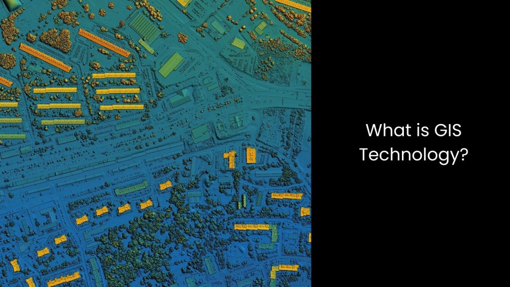
- GIS technology, or Geographic Information System technology, is a process that allows people to analyse, manage, and visualise spatial data in ways that make complex information easier to understand. This technology works by combining maps with data layers, enabling users to see relationships, patterns, and trends connected to specific locations.
- GIS mapping plays a significant role in urban planning, disaster management, agriculture, and even healthcare, offering insights to solve real-world problems. Instead of just looking at a static map, GIS mapping provides interactive tools where users can zoom in, toggle data layers, and predict future scenarios.
- What makes GIS unique is its ability to mix data from various sources, like satellite imagery, weather reports, and on-ground surveys, into one unified platform. This helps decision-makers act faster and smarter.
What Can GIS Do for Wildfire Risk Assessment and Mitigation?
Hazard Mapping
GIS technology plays a massive role in wildfire risk assessment and mitigation by making hazard mapping more efficient and accurate. It allows experts to identify and map high-risk wildfire zones based on vegetation density, weather patterns, and historical fire data. This powerful tool does not just present raw data; it combines layers of information to create detailed maps that highlight areas most vulnerable to fires.
In a way, GIS mapping enables researchers to track and analyse how environmental factors, like dry vegetation or wind direction, contribute to wildfire risks. This helps communities and emergency planners take proactive steps, such as clearing high-risk vegetation, setting up firebreaks, or designing evacuation routes. In another way, the ability of GIS technology to integrate real-time satellite imagery with historical patterns makes it even more helpful, especially during active wildfire events.
Experts can use it to monitor how fires spread and determine the most effective resource deployment locations. Hazard mapping with GIS also helps educate the public by showing clear visuals of danger zones and safe areas, which promotes better preparedness.
Whether assessing long-term risks or responding to immediate threats, GIS technology simplifies complex spatial data and makes decision-making faster and smarter.
Fuel Load Analysis
It is possible to analyse and monitor vegetation types, density, and moisture content to determine areas with significant fuel for wildfires.
What does this indicate? This means that GIS mapping can organise this information into clear visuals, helping firefighters, land managers, and decision-makers understand where the highest risks lie. Dry grasslands, dense forests, and other fuel-rich zones become easy to pinpoint, allowing experts to prioritise prevention efforts.
GIS technology does not just stop at identifying fuel loads; it also tracks changes over time, revealing how weather, seasonal cycles, or human activity might increase or reduce fire risks in specific areas. With real-time satellite data and on-the-ground measurements, GIS mapping creates dynamic maps that reflect current conditions. This ensures that mitigation strategies, like controlled burns or vegetation clearing, happen in the right places.
It also helps emergency teams predict how a fire might behave if it starts, guiding them on where to focus their efforts. Plus, GIS technology transforms overwhelming amounts of raw data into actionable insights, which helps reduce wildfire threats more effectively.
Real-Time Fire Tracking
It helps monitor active wildfires using satellite imagery and drone data, providing real-time updates to emergency responders. This capability ensures that teams on the ground have accurate, up-to-the-minute information about a fire’s location, size, and movement.
GIS mapping combines this live data with other layers, such as terrain and weather conditions, to create clear visuals that decision-makers can use immediately. Firefighters can identify safe access routes, predict how the fire might spread, and adjust their strategies as conditions change.
Real-time fire tracking also supports evacuation efforts by showing which areas are at immediate risk, helping authorities guide communities to safety.
Also, GIS technology’s ability to integrate multiple data sources ensures no critical detail is missed, making every second count during a wildfire emergency. With tools that highlight hotspots and fire boundaries, GIS mapping simplifies complex data, turning it into actionable plans.
As you can see, this technology does not just support response efforts but helps with post-fire recovery by mapping the most affected areas. Whether saving lives or protecting landscapes, GIS technology offers a more innovative, faster way to handle wildfire challenges.
Wildfire Simulation Models
GIS technology helps wildfire risk assessment and mitigation through its ability to create wildfire simulation models that predict fire behaviour under various conditions. Did you know this?
GIS can simulate fire spread under different scenarios, including wind, temperature, and terrain, to predict potential impacts and plan responses. This capability gives emergency teams a clear picture of how fast and far a wildfire might move, helping them decide where to focus firefighting efforts.
Also, GIS mapping allows experts to layer information like vegetation types, weather patterns, and slope angles, creating a detailed analysis of the factors influencing a fire’s path.
These simulations enable firefighters to anticipate high-risk zones and plan containment strategies before a fire grows out of control. Decision-makers can also use these models to test ‘what-if’ scenarios, such as how a wind speed or direction change might alter a fire’s trajectory. This level of insight helps allocate resources effectively and improves the safety of responders and communities.
So, GIS technology not only does forecasting fire behaviour, but it provides interactive tools that make the data easy to understand for everyone involved.
Risk Assessment for Communities
The best benefit of GIS is its ability to assess risks to human populations, infrastructure, and natural resources.
It prioritises areas that need immediate attention, making response efforts more focused and effective. GIS mapping collects and organises data from multiple sources, including population density, building locations, and natural features, to provide a clear view of areas most vulnerable to wildfires. Experts use this information to identify neighbourhoods, roads, and critical facilities at the highest risk, ensuring emergency plans target the correct locations.
It is not just highlighting the risks. GIS shows how fires might affect surrounding environments and communities. It allows planners to understand how a wildfire could disrupt transportation, damage utilities, or threaten water sources. This helps prioritise mitigation efforts, like creating defensible spaces around homes, reinforcing infrastructure, or establishing evacuation routes.
Emergency teams can also communicate risks more effectively to residents using easy-to-read maps. GIS mapping turns complex data into actionable insights, making wildfire response and planning smarter and faster.
Streamlining Wildlife Risk Assessment and Mitigation with the Help of GIS Technology
So, it is inevitable that GIS technology gives us hope in the face of wildfire devastation! It equips us with tools to detect dangers early, map risks accurately, and respond swiftly. With GIS technology, countries can enter a world where they can protect communities and nature with foresight and precision.