Soil erosion is not just an environmental issue. Yes, it is a global economic and ecological threat. According to the United Nations, over 24 billion tons of fertile soil are lost every year, reducing agricultural productivity and increasing infrastructure damage risks. In Australia alone, erosion costs agriculture billions annually due to declining soil fertility and land degradation.
That is why understanding and applying the right erosion control methods is essential for protecting ecosystems, maintaining compliance, and ensuring long-term land sustainability.
In this article, we explore practical strategies, real-world applications, and modern technologies shaping erosion management today.
The article covers
- What Is Erosion and Why Does Controlling It Matter?
- What Are the Main Types of Soil Erosion?
- What Are the Australian EPA and IECA Requirements for Erosion Control?
- How Does Vegetation Provide Effective Erosion Control?
- What Physical Barriers and Structural Methods Control Erosion?
- How Does Mulching and Soil Amendment Support Erosion Prevention?
- How Are Drainage Solutions Used to Manage Erosion from Stormwater?
- What Are Construction Site-Specific Erosion Control Strategies?
- What Common Mistakes Undermine Erosion Control Effectiveness?
- How Can Remote Sensing and GIS Optimise Erosion Management?
- How Does Digital Technology Enhance Erosion Control Monitoring?
- How to Transition from Planning to Implementation?
- FAQs About Erosion Control Methods
What Is Erosion and Why Does Controlling It Matter?
Erosion is a natural process, but human activity has accelerated it at dangerous levels. For landowners, engineers, and environmental planners, understanding erosion is the first step toward effective soil erosion prevention and long-term sustainability.
Key Takeaways
- Effective erosion control combines vegetation, structural barriers, and smart drainage systems.
- Early planning and phased construction significantly reduce soil loss and compliance risks.
- Digital technologies such as AI, GIS, and sensors enable proactive, data-driven erosion management.
- Long-term success depends on continuous monitoring, maintenance, and sustainable land practices.
Defining Erosion as the Displacement of Soil by Water, Wind, and Human Activity
Erosion refers to the movement of soil particles from one location to another due to forces like water erosion, wind erosion, and human disturbances such as construction or agriculture.
This process removes nutrient-rich topsoil. This leaves the land less fertile and more vulnerable to damage.
In modern contexts, erosion is often linked with sediment transport, where displaced soil travels into waterways, affecting ecosystems. Without proper management, erosion can degrade landscapes rapidly, making recovery difficult and costly.
The Difference Between Natural Erosion and Accelerated Human-Induced Erosion
Let’s explore the difference between these two.
Natural erosion occurs gradually over time and helps shape landscapes. However, human-induced erosion, often called accelerated erosion, happens much faster due to deforestation, urban development, and poor land practices.
Plus, activities like construction site erosion and unsustainable farming disrupt natural soil structure. This increases runoff and reduces vegetation cover, speeding up soil loss.
Unlike natural processes, accelerated erosion often exceeds the land’s ability to recover, leading to long-term damage.
Why Erosion Control Methods Are Critical for Land, Water Quality, and Compliance
Effective erosion control methods protect not only land but also water systems. When soil erodes, it carries pollutants into rivers and lakes, harming aquatic life and drinking water quality.
Additionally, regulations require strict adherence to environmental standards, including Australian EPA erosion compliance.
This is where failure to implement proper controls can result in fines, delays, and reputational damage. Strong erosion management ensures compliance while supporting sustainable development and land degradation management.
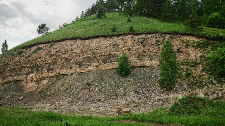
What Are the Main Types of Soil Erosion?
From sheet erosion, rill, splash, gully, to wind erosion, understanding soil erosion types is essential for selecting the right control strategies. Each type behaves differently and requires targeted solutions to minimise damage.
1. Sheet Erosion: Uniform Removal of Topsoil Across a Surface by Rainfall and Runoff
Sheet erosion occurs when a thin layer of soil is removed evenly across a surface due to rainfall and runoff. It is often difficult to detect early because it happens gradually.
Despite its subtle nature, sheet erosion significantly impacts topsoil protection, reducing soil fertility over time.
Without intervention, it can evolve into more severe erosion forms, making early detection critical for effective management.
2. Rill Erosion: Small Channel Formations Carved by Concentrated Water Flow
Rill erosion develops when runoff water concentrates into small channels, carving shallow paths into the soil.
These rills are typically a few centimeters deep but can expand if left untreated. This type of erosion often signals poor drainage or inadequate stormwater runoff management.
Addressing rill erosion early helps prevent progression into more damaging forms, such as gullies.
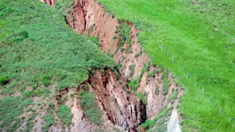
3. Gully Erosion: Deep Channels Formed When Rill Erosion Is Left Unchecked
Gully erosion is a more advanced stage where small rills expand into large channels. These gullies can become several meters deep, making land unusable and difficult to restore. It is one of the most destructive forms of land degradation.
The latter often requires significant engineering solutions. Preventing gully formation through early intervention is far more cost-effective than repairing it later.
4. Wind Erosion: Dry, Bare Soil Particles Lifted and Transported by Wind Forces
Wind erosion occurs in dry, exposed areas where loose soil is easily lifted and transported by wind. This is common in arid and semi-arid regions.
The absence of vegetation cover increases vulnerability, allowing fine particles to travel long distances. This not only depletes soil nutrients but also contributes to air pollution and reduced visibility.
5. Splash Erosion: Raindrop Impact Dislodging Surface Soil Particles
Splash erosion happens when raindrops hit bare soil, dislodging particles and causing them to move short distances.
While it may seem minor, it plays a key role in initiating other erosion types.
Repeated impact weakens soil structure and contributes to surface sealing, reducing infiltration. Over time, this leads to increased runoff and further erosion.
What Are the Australian EPA and IECA Requirements for Erosion Control?
Compliance with environmental regulations is essential for any project involving land disturbance. Understanding IECA guidelines and regulatory frameworks helps organisations implement effective sediment control techniques.
EPA Requirements for Sediment and Drainage Management Plans on Construction Sites
The Environmental Protection Authority requires detailed plans for managing sediment and drainage on construction sites. These plans ensure that soil and pollutants do not leave the site.
A well-prepared ESCP plan outlines control measures, monitoring processes, and risk mitigation strategies. It is a mandatory requirement for most large-scale developments.
IECA Best Practice Erosion and Sediment Control (BPESC) Guidelines
The International Erosion Control Association provides industry-recognised best practices through BPESC guidelines. These standards help professionals design effective erosion and sediment control systems.
Following these guidelines ensures that projects meet both environmental and operational requirements, reducing risks and improving outcomes.
Erosion and Sediment Control Plans (ESCP): Mandatory Documentation Requirements
An ESCP is a detailed document outlining how erosion and sediment will be managed throughout a project lifecycle. It includes site assessments, risk analysis, and control strategies.
This documentation is essential for achieving EPA compliance Australia.
It ensures that projects meet legal and environmental obligations from start to finish.
State-Specific Regulations: Queensland, NSW, Victoria, and WA Variations
Each Australian state has its own regulatory requirements for erosion control. While the core principles remain consistent, specific rules may vary.
Understanding local regulations ensures smoother project approvals and avoids compliance issues. Tailoring erosion control strategies to state guidelines is a critical step in project planning.
Consequences of Non-Compliance: Fines, Project Delays, and Environmental Liability
Failing to meet regulatory requirements can lead to severe consequences. These include financial penalties, project shutdowns, and long-term environmental damage.
Non-compliance also increases legal risks and reputational harm. Implementing proper erosion control measures protects both the environment and project stakeholders.
How Does Vegetation Provide Effective Erosion Control?
Vegetation stabilises soil, reduces runoff, and supports long-term ecosystem health.
Root Systems Binding Soil Particles and Preventing Detachment
Plant roots act as natural anchors, holding soil particles together and preventing erosion. They improve soil structure and increase resistance to water and wind forces.
This biological form of soil stabilisation is highly effective, especially on slopes and disturbed land areas.
Native Deep-Rooted Plants as Long-Term Slope Stabilisation Strategies
Native plants with deep root systems provide strong and lasting stability. They are adapted to local conditions, making them more resilient and easier to maintain.
Using native species supports slope stabilisation strategies while enhancing biodiversity and ecosystem balance.
Temporary Seeding and Hydroseeding for Rapid Ground Cover Establishment
Temporary seeding and hydroseeding are used to quickly establish vegetation on bare soil. This provides immediate protection against erosion.
These methods are commonly applied on construction sites where rapid coverage is needed to prevent soil loss.
Cover Crops Protecting Bare Soil During Off-Seasons on Agricultural Land
Cover crops are planted during the off-season to protect the soil from erosion. They reduce runoff, improve soil structure, and enhance fertility.
This approach is widely used in sustainable agriculture and supports long-term soil health.
Riparian Vegetation Buffers Protecting Streambanks from Erosion
Vegetation along riverbanks, known as riparian buffers, helps stabilise soil and reduce erosion. These buffers filter pollutants and protect water quality.
They are essential components of sustainable land and water management systems.
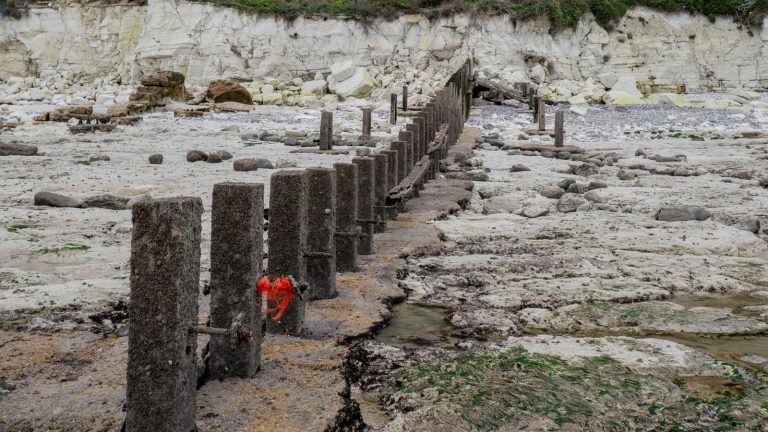
What Physical Barriers and Structural Methods Control Erosion?
Structural solutions are essential when natural methods alone are not enough. These approaches physically block, slow, or redirect water and sediment flow. They are widely used in construction, infrastructure, and high-risk areas where immediate protection is required.
Silt Fence Installation: Geotextile Barriers Trapping Sediment from Runoff
Silt fence installation is one of the most common methods used on construction sites.
These geotextile barriers are placed along slopes to capture sediment while allowing water to pass through slowly.
When installed correctly, silt fences act as a frontline sediment control technique, preventing soil from leaving the site. However, improper installation, such as poor trenching or loose fabric, can reduce effectiveness significantly.
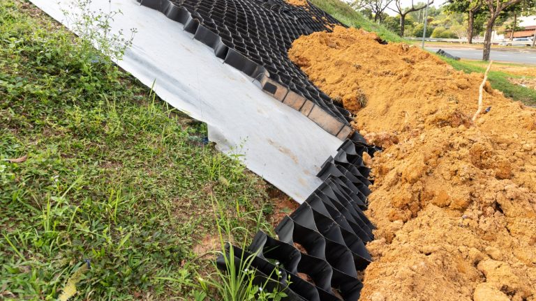
Erosion Control Blankets and Matting for Slope and Channel Protection
Erosion control blankets are used to cover exposed soil, especially on slopes and drainage channels.
These mats are typically made from biodegradable or synthetic materials that protect soil from rain impact and runoff.
They also support vegetation growth by retaining moisture and stabilising the surface. This makes them ideal for short- to medium-term protection in disturbed areas.
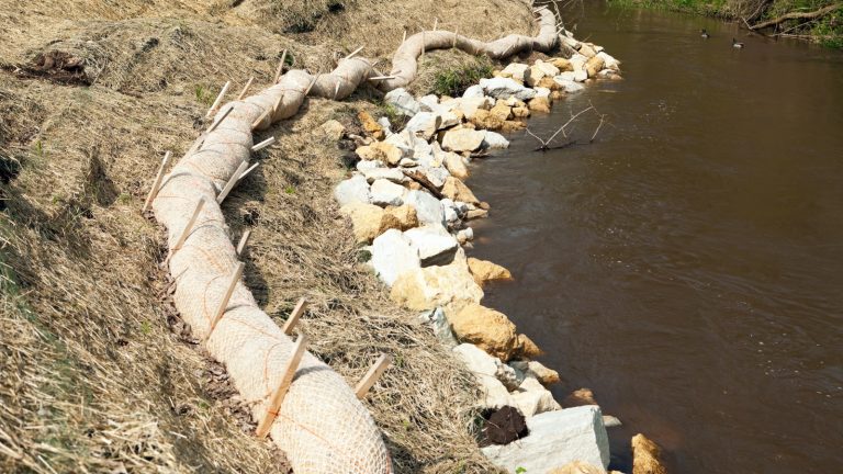
Riprap Placement: Rock Armouring Along Streambanks and Steep Slopes
Riprap placement involves using large stones or rocks to stabilise areas exposed to strong water flow.
It is commonly applied along riverbanks, shorelines, and steep slopes. This method reduces water velocity and protects soil from being washed away.
Moreover, riprap is highly durable and provides long-term protection, especially in high-energy environments.
Check Dams Slowing Water Velocity and Trapping Sediment in Drainage Channels
Check dams are small barriers built across drainage channels to slow water flow. By reducing velocity, they allow sediment to settle rather than being carried downstream.
These structures are particularly useful in controlling erosion in temporary drainage paths and construction zones. They are simple yet effective tools in managing sediment movement.
Sediment Basins Capturing Runoff Before Discharge Off-Site
A sediment basin is a designed area that collects runoff and allows sediment to settle before water is discharged. These basins are critical for large-scale projects where runoff volumes are high.
They play a major role in protecting nearby waterways and ensuring compliance with environmental regulations.
Gabions and Earth Walls for Permanent Bank Stabilisation
Gabions are wire mesh baskets filled with rocks, used to stabilise slopes and banks. Combined with earth walls, they provide strong structural support against erosion forces.
These solutions are long-lasting and are often used in infrastructure projects where permanent stabilisation is required.
How Does Mulching and Soil Amendment Support Erosion Prevention?
Soil treatments improve resistance to erosion by enhancing structure, moisture retention, and fertility. These approaches are especially effective when combined with vegetation and structural controls.
Mulch Materials Protecting Bare Soil from Raindrop Impact and Moisture Loss
Mulching techniques involve applying organic or inorganic materials over the soil to protect it. Mulch absorbs raindrop impact, reducing the risk of particle displacement.
It also retains moisture, which supports plant growth and reduces surface runoff. This makes mulching a simple yet powerful erosion prevention method.
Organic Compost Improving Infiltration and Reducing Surface Runoff Velocity
Adding organic compost improves soil structure by increasing porosity and water infiltration. This reduces the speed of runoff, lowering erosion risks.
Compost also enriches soil with nutrients, supporting vegetation growth and long-term stability.
Soil Binders and Polyacrylamide (PAM) Stabilising Disturbed Surfaces Temporarily
Soil binders, including polyacrylamide (PAM), are used to temporarily stabilise disturbed soil. They create a protective layer that holds particles together.
These solutions are commonly used in construction zones where vegetation has not yet been established.
Improving Soil Structure: pH and Fertility Corrections for Vegetation Establishment
Healthy soil is more resistant to erosion. Adjusting pH levels and improving fertility helps plants grow stronger roots, which stabilise soil.
This approach supports long-term erosion control by enhancing natural resilience.
Selecting the Right Amendment for Clay, Sandy, and Loamy Soil Types
Different soil types require different treatments.
Clay soils benefit from aeration and organic matter, while sandy soils need moisture retention improvements.
Choosing the right amendment ensures effective erosion prevention and sustainable land use.
How Are Drainage Solutions Used to Manage Erosion from Stormwater?
Proper drainage systems are critical for stormwater runoff management and protecting vulnerable land areas.
French Drains and Subsurface Drainage: Redirecting Water Underground
French drains are underground systems that collect and redirect water away from problem areas. They reduce surface water flow, preventing erosion. These systems are especially useful in areas prone to waterlogging and soil instability.
Swales and Diversion Channels Directing Runoff Away from Vulnerable Soil
Swales and diversion channels guide water safely away from sensitive areas.
By controlling flow direction, they reduce the risk of soil displacement. These features are commonly used in landscaping and agricultural applications.
Terracing and Grade Breaks: Reducing Slope Length and Runoff Velocity
Terracing divides slopes into smaller sections. They reduce the distance water can travel.
This slows runoff and minimises erosion.
Grade breaks further reduce water speed, making them effective on steep terrain.
Stormwater Management Pipes Rerouting Flow from High-Risk Erosion Areas
Pipes and drainage systems are used to safely transport water away from erosion-prone zones. These systems prevent uncontrolled runoff.
They are essential in urban developments and infrastructure projects.
Permeable Surfaces and Green Infrastructure Absorbing Runoff at Source
Permeable materials allow water to soak into the ground rather than flow over the surface.
This reduces erosion and supports groundwater recharge. Green infrastructure, such as rain gardens, enhances natural water absorption and sustainability.
What Are Construction Site-Specific Erosion Control Strategies?
Construction sites are highly vulnerable to erosion due to exposed soil. Effective construction site erosion control requires planning, monitoring, and continuous management.
Creating an Erosion and Sediment Control Plan (ESCP) Before Breaking Ground
An ESCP plan is essential before starting any construction project. It outlines risks and control measures.
It also helps with monitoring strategies.
Proper planning ensures that erosion risks are managed from the beginning.
Construction Phasing to Minimise Exposed Soil at Any One Time
Phasing construction activities reduces the amount of exposed soil. This limits erosion risks and makes control measures more effective.
It is a key strategy in sustainable construction management.
Stabilising Site Entry and Exit Points to Prevent Tracking
Stabilised entry points prevent soil from being carried off-site by vehicles. This reduces environmental impact and maintains site cleanliness. It also helps meet regulatory requirements.
Progressive Stabilisation Using Temporary Seeding and Erosion Mats
Gradual stabilisation ensures that the soil is protected as construction progresses.
Temporary seeding and mats provide immediate coverage. This approach reduces the risk of erosion during active construction phases.
Regular Site Inspections and Maintenance of Erosion Control Measures
Ongoing inspections ensure that control measures remain effective. Maintenance is critical, especially after rainfall events.
Without regular checks, even well-designed systems can fail.
What Common Mistakes Undermine Erosion Control Effectiveness?
Even well-designed plans can fail if common mistakes are overlooked. Many erosion issues arise not from lack of effort but from poor execution or timing. Understanding these pitfalls helps improve the effectiveness of erosion control methods and ensures long-term results.
Failing to Plan Erosion Controls Before Earthworks Begin
One of the biggest mistakes is starting earthworks without a proper plan.
Without early planning, soil is exposed to rain and wind before any protection is in place. This leads to rapid erosion and sediment movement.
This is where a proactive approach ensures that controls are installed before disturbances occur, reducing risks and improving efficiency.
Incorrect Silt Fence Installation Rendering Barriers Ineffective
Improper installation is a common issue that reduces the performance of barriers. If fences are not trenched properly or secured tightly, water can bypass them easily.
This allows sediment to escape, defeating their purpose. Correct installation techniques and regular checks are essential to maintain effectiveness.
Neglecting Maintenance After Rainfall Events
Erosion control systems require regular maintenance, especially after heavy rain. Sediment buildup, damaged barriers, and blocked drainage can reduce system efficiency.
Ignoring these issues can lead to system failure. Routine inspections help identify and fix problems before they escalate.
Disturbing Too Much Land Area at Once Without Phased Stabilisation
Exposing large areas of soil at once increases erosion risk significantly.
Without phased stabilisation, runoff can carry large volumes of sediment. This makes control measures harder to manage. Gradual land disturbance allows for better control and easier stabilisation.
Selecting Non-Native Vegetation That Fails to Establish in Local Conditions
Using unsuitable plant species can lead to poor vegetation growth. Non-native plants may struggle to survive in local climates and soil conditions.
This reduces their ability to stabilise soil effectively. Choosing the right species ensures long-term success and resilience.
How Can Remote Sensing and GIS Optimise Erosion Management?
Modern technology is transforming how erosion is monitored and managed. Tools like remote sensing, land systems, and spatial analysis allow for more accurate and proactive decision-making.
These technologies help identify risks early and improve intervention strategies.
Satellite Imagery Identifying Areas Prone to Erosion and Habitat Loss
Using satellite imagery soil analysis, professionals can identify areas with high erosion risk. These images provide large-scale visibility of land conditions over time.
Changes in vegetation, soil exposure, and water flow can be tracked accurately. This helps prioritise intervention areas and allocate resources effectively.
GIS Mapping Soil Types, Slope Gradients, and Land Use for Targeted Interventions
GIS erosion mapping enables detailed analysis of land characteristics. By combining data on soil type, slope, and land use, planners can design targeted solutions. This improves the efficiency of erosion control measures. It also helps reduce unnecessary interventions, saving time and cost.
NDVI Indices Monitoring Vegetation Health and Identifying Exposed Soil
NDVI (Normalised Difference Vegetation Index) is used to assess vegetation health. It highlights areas with low vegetation cover, which are more prone to erosion. This allows for early detection of potential problem zones. Monitoring vegetation health supports better planning and timely action.
Drone Aerial Surveys Mapping Erosion Progression Across Large Sites
Drone monitoring provides high-resolution images of large areas quickly. Drones can capture detailed views of erosion patterns and site conditions.
This helps track changes over time and evaluate the effectiveness of control measures. It is especially useful for large or hard-to-access locations.
Remote Sensing Data Informing Erosion Control Plan Design and Updates
Data collected from remote sensing tools supports better planning and decision-making. It provides real-time insights into land conditions and erosion risks. This information helps update and refine control strategies.
As a result, erosion management becomes more adaptive and effective.
How Does Digital Technology Enhance Erosion Control Monitoring?
Digital tools are redefining how erosion is managed in modern environments. From sensors to predictive analytics, technology enables real-time monitoring and smarter decision-making. These innovations improve efficiency and support proactive land management.
IIoT Sensor Networks Monitoring Soil Moisture, Rainfall, and Slope Stability in Real Time
IIoT sensors are deployed across sites to monitor key environmental factors. These sensors track soil moisture, rainfall intensity, and slope movement continuously.
Real-time data helps identify potential erosion risks before they escalate. This allows for faster response and improved control.
AI Analytics Forecasting Erosion Risk from Sensor Data and Weather Patterns
AI predictive analytics processes large volumes of data to identify patterns and trends. It can forecast erosion risks based on weather conditions and historical data. This helps planners take preventive actions in advance.
AI-driven insights improve decision-making and reduce uncertainty.
Digital Twin Modelling, Simulating Erosion Events, and Testing Control Strategies
Digital twin erosion models create virtual representations of physical environments. These models simulate erosion scenarios under different conditions.
This allows engineers to test and optimise control strategies before implementation. It reduces risks and improves project outcomes.
GIS-Integrated Dashboards Providing Spatial Views of Erosion Hotspots
GIS-integrated dashboards combine data from multiple sources into a single interface. They provide visual insights into erosion hotspots and land conditions.
This helps teams understand spatial relationships and prioritise actions. It enhances coordination and decision-making across projects.
Automated Compliance Reporting for EPA and Regulatory Requirements
Digital systems can generate automated reports for regulatory compliance. These reports track performance and document control measures.
This simplifies the process of meeting environmental standards. It also reduces administrative workload and improves transparency.
How to Transition from Planning to Implementation?
Planning is only effective when it leads to proper execution. Transitioning from strategy to action requires coordination, compliance, and continuous monitoring.
This stage ensures that erosion control methods are correctly applied and maintained for long-term effectiveness.
Early Integration of Erosion Control into Site Design, Grading, and Layout
Erosion control should be considered from the earliest design stages. Integrating controls into grading and layout reduces the need for reactive fixes later.
This approach ensures that water flow, slopes, and soil exposure are managed proactively. Early planning improves efficiency and reduces long-term costs.
Compliance Verification: EPA/IECA Requirements and ESCP Documentation
Before implementation, all compliance requirements must be verified. This includes aligning with regulatory standards and ensuring documentation is complete. Reviewing plans against environmental guidelines reduces the risk of violations.
Proper verification builds confidence that the project meets all legal and environmental expectations.
Construction Supervision Ensuring Correct Barrier Installation and Soil Disturbance Limits
Supervision during construction is critical to ensure proper implementation. Even well-designed systems can fail if installed incorrectly.
Monitoring ensures that barriers, drainage systems, and controls are placed correctly. It also helps limit unnecessary soil disturbance, reducing erosion risks.
Commissioning: Testing Drainage Systems and Vegetation Establishment Under Rainfall Events
Once systems are installed, they must be tested under real conditions. Rainfall events provide valuable insights into system performance. Testing helps identify weaknesses in drainage or vegetation coverage.
This allows for adjustments before issues become serious.
Ongoing Education: Site Team Training on Erosion Control Responsibilities and Inspections
Training ensures that all team members understand their roles in erosion control.
Educated teams are more likely to follow best practices and maintain systems effectively. Regular training sessions improve awareness and accountability. This supports long-term success and continuous improvement.
Why Choose Tigernix for Erosion Monitoring and Land Management?
Modern erosion management requires more than traditional methods. Tigernix provides advanced digital solutions that combine monitoring, analytics, and automation to improve outcomes and efficiency.
Smart Sensor Networks Monitoring Soil Moisture, Slope Stability, and Rainfall in Real Time
Tigernix uses advanced sensor networks to continuously monitor environmental conditions. These systems provide real-time data on soil moisture, rainfall, and slope stability. This helps detect early signs of erosion risk.
With accurate data, site managers can take timely action.
Digital Twin Technology Simulating Erosion Events and Testing Prevention Scenarios
Tigernix Solutions employs digital twin technology to model erosion scenarios. These simulations allow users to test different strategies before implementation.
This reduces uncertainty and improves planning accuracy. It also helps optimise resource allocation and system design.
AI Analytics Identifying Erosion Risk Patterns and Predicting Sediment Transport
Our solution’s AI-powered analytics identify patterns in environmental data. These insights help predict erosion risks and sediment transport trends.
This allows for proactive decision-making and better resource management. Predictive capabilities improve overall efficiency and effectiveness.
GIS Integration Mapping Land Exposure, Erosion Hotspots, and Control Performance
Tigernix integrates GIS technology to provide detailed spatial insights. It maps land exposure, identifies erosion hotspots, and tracks performance of control measures. This helps teams prioritise actions and allocate resources effectively.
Spatial data enhances decision-making and planning.
Real-Time Dashboards Enabling Site Managers to Optimise Erosion Control Proactively
Interactive dashboards provide a clear overview of site conditions. Your managers can monitor performance, track changes, and respond quickly to issues. These tools improve coordination and communication across teams.
Real-time insights enable proactive management rather than reactive responses.
Tigernix-For Better Erosion Control
Ready to Strengthen Your Erosion Control and Land Management?
Taking action is the final step in building an effective erosion control strategy. With the right tools, expertise, and approach, organisations can protect land, meet compliance requirements, and improve long-term sustainability.
Schedule a Consultation with Tigernix Land and Environmental Technology Specialists
Engaging with experts ensures that your erosion control strategy is tailored to your needs. Tigernix specialists provide insights based on data, experience, and advanced technology. This helps you implement effective solutions with confidence. Expert guidance reduces risks and improves outcomes.
Call for a free demo.
Discover How Smart Monitoring Enhances Erosion Control Method Effectiveness
Smart monitoring systems provide continuous insights into site conditions. These systems improve the effectiveness of control measures by enabling timely interventions. Data-driven approaches lead to better decision-making. This enhances overall performance and sustainability.
Implement Digital Systems Maximising Land Protection and Regulatory Compliance
Digital solutions streamline monitoring, reporting, and compliance processes. They help ensure that all requirements are met efficiently. Automation reduces manual effort and improves accuracy. Implementing these systems supports long-term land protection and regulatory success.
FAQs About Erosion Control Methods
The most effective erosion control methods for construction sites include silt fences, sediment basins, temporary seeding, and proper drainage systems. These methods reduce soil exposure, control runoff, and prevent sediment from leaving the site while ensuring compliance with environmental regulations.
Vegetation helps prevent soil erosion by using root systems to bind soil particles and reduce runoff velocity. Plants also protect soil from the impact of rain and improve water absorption, making vegetation one of the most sustainable and cost-effective erosion-control solutions available today.
Sheet erosion removes a thin, uniform layer of soil, often unnoticed. Rill erosion creates small channels from concentrated water flow. Gully erosion is more severe, forming deep channels that can damage land permanently if not managed early and effectively.
Stormwater management is important because uncontrolled runoff is a major cause of soil erosion. Proper drainage systems, swales, and permeable surfaces help control water flow, reduce soil displacement, and protect land, infrastructure, and nearby water bodies from damage.
Technology improves erosion control by using sensors, AI analytics, GIS mapping, and digital twins to monitor conditions in real time. These tools help predict risks, optimise control strategies, and ensure compliance with environmental regulations through automated reporting and data-driven decision-making.