If you look into the climate changes carefully, you will notice that floods that were once called ‘rare’ are now showing up far more often, and with greater intensity. According to the World Meteorological Organisation, extreme weather events have increased by over 30% in the past two decades, with floods leading the trend.
That shift is forcing catchment managers to rethink how they plan, test, and respond. Instead of waiting for disasters, many are now turning to digital-twin catchment flood scenarios to simulate future events before they arrive.
This article explores how advanced simulation, AI, and real-time data can help you test and prepare for extreme flood conditions, without ever facing the actual risk.
We will discover
- What Is a 1-In-100-Year Flood Event?
- Why Catchment Managers Need Scenario Testing
- What Is a Digital Twin For Catchment Systems?
- How Digital Twin Flood Scenarios Are Built
- How AI Weather Forecasting Enhances Scenarios
- How IIoT Sensors Feed Real-Time Flood Simulation
- How GIS Mapping Visualises Flood Risk Zones
- How Operators Are Trained Using Flood Scenarios
- How Digital Twin Protects Catchment Assets During Floods
- How Scenario Testing Reduces Flood Damage And Costs
- Common Gaps Without Digital Twin Flood Testing
- How To Build A Digital Twin Flood Testing Programme
- FAQs About Digital Twin Catchment Flood Scenarios
What Is a 1-in-100-Year Flood Event?
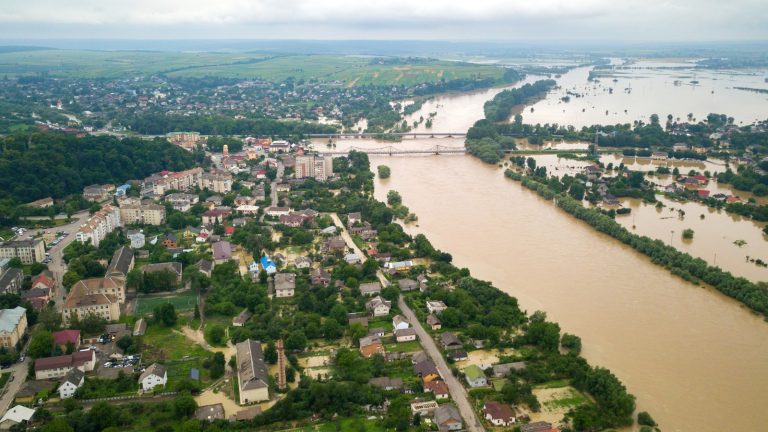
A 1-in-100-year flood event refers to a flood that has a 1% chance of occurring in any given year. However, due to climate change and land-use changes, these events are happening more frequently.
Key Takeaways
- Digital twin systems help simulate extreme floods before they happen. This improves planning and reduces uncertainty in catchment operations.
- Real-time sensor data and AI forecasting make flood predictions more accurate and responsive.
- Scenario testing helps identify weak infrastructure points early, and it reduces costly failures and emergency repairs during floods.
- GIS mapping and simulation tools improve visibility of flood risk zones to help protect both assets and surrounding communities.
Defining Annual Recurrence Interval
The term ARI, or annual recurrence interval, describes how often a specific flood level is expected to occur.
It does not mean the flood happens only once every 100 years. Instead, there is a 1% chance of occurrence each year.
This probability-based approach helps engineers estimate risk levels.
However, relying only on historical ARI values is becoming less reliable due to changing weather patterns and evolving catchment conditions.
Why 1-In-100-Year Events Are Increasing
A 1-in-100-year flood is no longer as rare as it once was. Climate change is increasing rainfall intensity, while urbanisation reduces natural drainage.
These combined factors lead to higher runoff and faster flooding. For example, many regions now record multiple ‘100-year’ floods within a decade.
This trend highlights the need for dynamic simulation tools that adapt to new data rather than relying solely on historical averages.
Consequences For Catchment Infrastructure
Flooding at this scale can overwhelm drainage systems, damage dams, and disrupt water networks. Infrastructure designed decades ago may not handle today’s flood volumes.
Increased catchment runoff can push systems beyond their limits, causing failures. Roads, pipelines, and reservoirs face severe stress during peak conditions.
Without proactive testing, these vulnerabilities remain hidden until a real disaster occurs, leading to costly repairs and long recovery times.
Why Traditional Planning Tools Fall Short
Traditional flood models rely heavily on static datasets and simplified assumptions. They often fail to capture real-time changes in catchment hydrology. As a result, predictions may be inaccurate during extreme events.
These tools also lack integration with live sensor data and cannot simulate complex system interactions. This makes it difficult for operators to respond quickly and effectively. Modern challenges require more dynamic and adaptive approaches, like digital twin catchment flood scenarios.
Why Catchment Managers Need Scenario Testing
Scenario testing allows managers to simulate extreme flood events in a safe, controlled environment. It helps identify risks, test response strategies, and improve decision-making before a real flood occurs.
Pre-Planning Gate Releases Before Flood Peaks
Managing dam gate release timing is critical during floods.
Releasing water too early wastes storage capacity, while releasing it too late increases downstream flooding. Scenario testing helps determine the optimal timing based on predicted inflow. By simulating different rainfall conditions, managers can plan releases more accurately.
This approach is especially useful for dam gate release planning Australia, where large reservoirs must balance flood control and water supply needs.
Training Operators Without Real Flood Risk
Flood events are dangerous and unpredictable, making real-world training difficult. Scenario simulations provide a safe environment for operator simulation. Teams can practice handling emergencies without real consequences.
This improves confidence and decision-making skills. It also ensures that staff are familiar with systems and protocols before an actual event occurs, reducing the chance of human error during critical moments.
Identifying Vulnerable Assets In Advance
Flood simulations help identify weak points in infrastructure. By analysing system performance under stress, managers can detect risks early.
This improves catchment asset flood resilience by allowing targeted upgrades and maintenance. Instead of reacting to failures, organisations can take preventive action.
This proactive approach saves both time and money while improving overall system reliability.
Building Community Preparedness Strategies
Flood preparedness goes beyond infrastructure.
Communities need clear plans and communication strategies. Scenario testing supports community preparedness by identifying high-risk areas and evacuation needs. Authorities can develop better warning systems and response plans. This reduces panic and improves safety during real events.
It also builds trust between communities and water management agencies.
What Is a Digital Twin For Catchment Systems?
A digital twin is a virtual model of a physical system that updates in real time. In catchment management, it replicates infrastructure, water flows, and environmental conditions to support better decision-making.
Replicating Catchment Infrastructure Virtually
A digital twin creates a detailed virtual replica of the entire catchment system. This includes dams, pipelines, rivers, and drainage networks.
Using digital twin simulation, managers can visualise how water moves through the system. This allows for better planning and analysis.
The model continuously updates with new data, making it more accurate than traditional static models.
Simulating Precipitation To Groundwater Recharge
Flood scenarios must consider the full water cycle. Digital twins simulate rainfall, runoff, and groundwater recharge processes. This helps predict how water moves through soil and into aquifers.
When they understand these interactions, managers can better manage water resources during floods. It also improves long-term planning for both flood control and water supply.
Comparing Actual Vs Desired Performance Levels
Digital twins allow managers to compare real system performance with expected outcomes. This helps identify gaps and inefficiencies. Metrics like the asset integrity index can be used to assess infrastructure health.
If performance drops below acceptable levels, corrective actions can be taken immediately. This continuous monitoring improves reliability and reduces the risk of unexpected failures.
Live Sync With IIoT And Sensor Data
Modern catchment systems use IIoT flood sensors to collect real-time data. These sensors monitor rainfall, water levels, and structural conditions. The digital twin integrates this data to provide accurate, up-to-date insights.
This live connection enables faster responses and better decision-making.
It also ensures that simulations reflect actual conditions, making them more reliable.
How Digital Twin Flood Scenarios Are Built

Building accurate flood scenarios requires combining historical data, predictive models, and real-time inputs. This process ensures that simulations reflect both past trends and future risks.
1. Inputting Historical Rainfall And Radar Data
The foundation of any flood model is historical rainfall data. This data helps establish baseline conditions and identify patterns.
In addition, rainfall radar provides spatial and temporal insights into storm behaviour. By combining these datasets, digital twins can create realistic rainfall scenarios.
This improves the accuracy of simulations and helps predict how future storms may behave.
2. Modelling Peak Discharge And Runoff Volumes
Understanding peak discharge is critical for flood management. Digital twins use advanced models to estimate how much water will flow through rivers and channels during a storm.
A rainfall runoff model calculates how rainfall translates into surface flow.
These calculations help predict flood intensity and timing. Accurate modelling ensures that infrastructure can handle expected loads.
3. Setting 1-In-100-Year Rainfall Parameters
To simulate extreme events, models must include parameters for a 1-in-100-year flood event Australia.
These parameters define rainfall intensity, duration, and distribution. By adjusting these variables, managers can test different scenarios. This helps identify potential risks and evaluate system performance under extreme conditions.
4. Running Hydraulic Simulations Across Catchment Zones
Digital twins use hydraulic modelling to simulate water movement across the catchment. This includes rivers, reservoirs, and drainage systems. A hydraulic flood modelling digital twin can show how water levels change over time.
It also helps identify bottlenecks and overflow points. These insights are essential for improving flood response strategies and reducing damage.
How AI Weather Forecasting Enhances Scenarios
AI-driven forecasting improves flood simulations by predicting weather patterns before they happen. It combines multiple data sources to provide early warnings and more accurate flood scenarios.
Analysing Satellite Data And Radar Patterns
AI systems process large volumes of data from satellite radar patterns and weather stations. This includes cloud movement, temperature, and moisture levels. By analysing these inputs, AI can detect early signs of heavy rainfall.
Unlike traditional methods, AI identifies subtle changes that humans might miss. This leads to faster and more accurate predictions.
Integrating these insights into digital twin catchment flood scenarios allows managers to prepare well before storms develop.
Predicting Storm Events Before They Arrive
With advanced algorithms, AI enables reliable storm event prediction. It uses historical trends and live data to forecast when and where storms will occur. This gives catchment managers valuable lead time to act.
Early predictions help reduce uncertainty and improve planning. When combined with simulation tools, these forecasts allow teams to test different responses in advance, ensuring better preparedness.
Pre-Planning Dam Gate Releases Proactively
AI forecasting supports proactive dam gate release strategies. Instead of reacting to rising water levels, managers can plan releases based on predicted inflows. This reduces the risk of sudden flooding downstream.
It also ensures efficient water storage management. By integrating forecasts into digital twin catchment flood scenarios, operators can test multiple release strategies and choose the safest option.
Mitigating Flood Risk Across Reservoirs And Rivers
AI helps manage water systems more effectively by improving reservoir flood routing. It predicts how water will move through reservoirs and rivers during a storm.
This allows managers to balance inflows and outflows more efficiently. The result is reduced flood risk and better protection for downstream communities.
Combining AI with simulation tools ensures that responses are both timely and accurate.
How IIoT Sensors Feed Real-Time Flood Simulation
IIoT sensors provide real-time data that keeps digital twin models accurate and responsive. These sensors act as the eyes and ears of the catchment system.
Stream Gauges And Water Level Sensors
Sensors placed in rivers and channels continuously collect stream gauge data. This includes flow rates and real-time water level measurements.
These inputs help digital twins accurately track current conditions. By monitoring changes in water levels, managers can detect early signs of flooding.
This real-time visibility improves decision-making and response speed during critical events.
Real-Time Structural Integrity Monitoring On Dams
Dams face significant stress during floods. Sensors monitor pressure, vibration, and structural conditions to ensure safety. This data supports water level monitoring and helps detect potential failures early. By feeding this information into digital twins, managers can assess risks in real time.
This reduces the chance of unexpected structural damage and improves overall system safety.
Spillway And Pipeline Sensor Data Streaming
Spillways and pipelines play a key role in flood management. Sensors track flow rates, pressure, and performance, supporting effective spillway management.
This data helps identify blockages or inefficiencies. Continuous monitoring ensures that these systems operate as expected during peak conditions.
Digital twins use this data to simulate different scenarios and optimise system performance.
Triggering Automated Alerts At Threshold Levels
IIoT systems can trigger alerts when conditions exceed safe limits.
For example, rising water levels or pressure spikes can activate warnings. This is critical for preventing stormwater overflow and combined sewer overflow events.
Automated alerts allow operators to act quickly, reducing damage and improving response times. Integrating these alerts with digital twin catchment flood scenarios ensures coordinated action across the system.
How GIS Mapping Visualises Flood Risk Zones

GIS technology transforms complex flood data into clear, visual insights. It helps managers understand where risks exist and how they impact infrastructure.
Inundation Mapping Across Catchment Areas
GIS tools create detailed inundation mapping visuals that show how water spreads during floods. These maps highlight affected areas and depth levels. This helps managers understand the extent of flooding.
It also supports planning for evacuation and emergency response. Visual data makes it easier to communicate risks to stakeholders and communities.
Identifying Flood-Prone Infrastructure Locations
Using catchment area mapping, GIS systems identify infrastructure located in high-risk zones. This includes roads, pipelines, and buildings. By understanding these risks, managers can prioritise upgrades and protective measures. This reduces vulnerability and improves system resilience.
It also ensures that resources are allocated effectively.
Overlaying Asset Condition And Flood Exposure
GIS allows multiple data layers to be combined. For example, asset condition data can be overlaid with flood risk information.
This helps evaluate infrastructure resilience under extreme conditions. Managers can identify which assets are most at risk and take preventive action.
This integrated view supports better decision-making and long-term planning.
Interactive GIS Views For Operator Decision-Making
Modern GIS platforms offer interactive dashboards for GIS flood mapping.
Operators can explore data in real time, adjust scenarios, and view impacts instantly. This improves situational awareness and response speed. It also supports collaboration between teams, ensuring that everyone has access to the same information.
For regions like GIS flood risk mapping Australia, this approach is becoming essential.
How Operators Are Trained Using Flood Scenarios
Training is essential for effective flood response. Digital simulations provide a safe and realistic environment for learning and practice.
Mockup Flood Events For Workforce Training
Simulated flood events allow teams to experience realistic scenarios without actual risk.
These exercises improve flood scenario modelling skills and build confidence.
Workers learn how systems behave under stress and how to respond effectively. This hands-on approach is more effective than traditional training methods, as it prepares teams for real-world challenges.
Valve Controller Simulation Under Peak Discharge
During floods, controlling water flow is critical. Simulations allow operators to practice valve controller training under high-pressure conditions. This includes safely managing peak discharge levels.
By practising these scenarios, operators become more skilled and confident. This reduces the risk of mistakes during actual events.
Practising Emergency Protocols Without Real Risk
Flood simulations provide a platform to test emergency flood protocol procedures.
Teams can practise coordination, communication, and decision-making. This ensures that everyone knows their role during an emergency.
It also helps identify gaps in existing plans. Regular practice improves readiness and reduces response times during real floods.
Building Agile Response Capabilities Pre-Event
Digital training helps teams develop flexible and adaptive strategies. By practising different scenarios, operators can adjust quickly to changing conditions.
This supports the development of a strong flood response plan. Agile teams are better prepared to handle unexpected challenges, improving overall system resilience.
How Digital Twin Protects Catchment Assets During Floods
Digital twins provide real-time insights that help protect infrastructure during extreme conditions. They allow managers to act quickly and prevent damage.
Assessing Asset Integrity Under Peak Flood Load
Flood conditions put immense pressure on infrastructure. Digital twins help evaluate performance using metrics like flood damage assessment and stress analysis.
This allows managers to understand how assets behave under load. Early detection of issues helps prevent failures and reduces repair costs.
Identifying Failure Points In Spillways And Pipelines
Simulations can reveal weak points in infrastructure. By analysing performance during extreme conditions, managers can identify potential failures. This includes pipelines, spillways, and drainage systems.
With our experience, we can assure you that addressing these issues early improves reliability and reduces the risk of catastrophic damage.
Simulating Damage Scenarios Before Physical Events
Digital twins enable advanced flood scenario modelling by testing different damage scenarios.
This helps managers prepare for worst-case situations. By understanding potential impacts, they can develop better response strategies. This proactive approach reduces uncertainty and improves preparedness.
Adjusting Infrastructure Response Plans In Real Time
Real-time data allows managers to adjust strategies during a flood. Digital twins provide insights into system performance, enabling quick decisions.
This flexibility helps minimise damage and maintain system stability. Integrating these capabilities into digital twin catchment flood scenarios ensures a more effective response.
How Scenario Testing Reduces Flood Damage and Costs

Scenario testing is not just about prediction; it directly reduces financial loss, infrastructure damage, and emergency response pressure. When simulating extreme floods in advance, catchment managers can act earlier and smarter.
Earlier Gate Release Reducing Downstream Inundation
One of the biggest advantages of simulation is timing dam gate release planning Australia more effectively.
When operators test different rainfall and inflow scenarios, they can decide the safest time to release water before reservoirs reach critical levels. This reduces sudden downstream surges and prevents large-scale flooding.
It also avoids emergency decisions made under pressure.
Over time, this proactive approach reduces damage to homes, roads, and agricultural land.
Avoiding Emergency Repairs Through Pre-Planned Action
Emergency repairs during floods are expensive and disruptive. Scenario testing helps identify weak points before failure occurs.
When managers use hydraulic flood modelling digital twin, they can predict where systems may break under stress. This allows them to schedule maintenance or upgrades in advance.
As a result, utilities avoid costly last-minute fixes and reduce downtime in critical water systems.
Protecting Neighbouring Ecosystems And Communities
Floods do not just damage infrastructure; they impact ecosystems, too.
Controlled scenario testing helps prevent sudden releases that could harm rivers and wetlands. By simulating stormwater flood scenario testing, managers can balance safety with environmental protection.
This ensures aquatic habitats are not overwhelmed by sudden flows.
It also reduces erosion and contamination risks, helping maintain ecological stability during extreme weather events.
Lowering Insurance And Infrastructure Repair Costs
Insurance claims after floods can be extremely high.
However, when risks are reduced through planning and simulation, overall claims decrease. Using catchment flood simulation Australia, authorities can justify lower-risk classifications for certain assets.
This often leads to reduced premiums and long-term savings. Preventing damage is always cheaper than repairing it, making scenario testing a financially smart investment.
Common Gaps Without Digital Twin Flood Testing
Without modern simulation tools, many catchment systems rely on outdated assumptions. This creates blind spots that increase flood risk and reduce response efficiency.
Operators Reacting Without Pre-Planned Protocols
In many systems, operators still rely on reactive decision-making. Without emergency flood protocol testing, teams may struggle during real events. This leads to delays, confusion, and inconsistent responses.
Digital simulation ensures every action is rehearsed and understood. Without it, even experienced teams can make costly mistakes under pressure.
Flood Damage Exposing Unidentified Asset Weaknesses
When floods occur without prior modelling, hidden weaknesses in infrastructure are often revealed too late. Systems that were never tested under stress may fail unexpectedly.
A lack of catchment asset flood resilience planning means repairs only happen after damage. This reactive approach increases long-term costs and reduces system reliability.
Missing Early Rainfall Warning Signals In Data
Traditional monitoring systems often fail to detect early warning signs. Without integrated rainfall radar and predictive models, important signals may be missed. This reduces lead time for action and increases flood impact.
Modern digital systems combine multiple data sources to improve early detection and forecasting accuracy.
Community Unpreparedness For Extreme Flood Events
Without scenario planning, communities are often caught off guard.
Poor communication and a lack of drills reduce readiness.
This is especially critical in areas exposed to a 1-in-100-year flood event Australia conditions.
Digital twins help simulate community impact zones, improving awareness and evacuation planning. Without them, response times are slower, and risks are higher.
How to Build a Digital Twin Flood Testing Programme

Building a structured flood testing programme requires combining data, technology, and planning frameworks. It ensures simulations are accurate and actionable.
1.Establishing A Full Catchment Asset Digital Model
The first step is creating a complete digital representation of the catchment.
This includes rivers, dams, pipelines, and drainage systems. A strong catchment hydrology model ensures water movement is accurately represented.
This foundation allows all future simulations to reflect real-world behaviour, making results more reliable and useful for decision-making.
- Defining 1-In-100-Year Scenario Parameters
Next, managers must define extreme event conditions. These include rainfall intensity, duration, and distribution for a 1-in-100-year flood. These parameters help simulate worst-case scenarios.
Since it is possible to adjust these values, teams can test multiple outcomes and improve preparedness for rare but high-impact events.
- Integrating IIoT, GIS, And AI Weather Data
A strong system integrates multiple technologies. IIoT flood sensors provide real-time input, while GIS systems support spatial mapping. AI tools enhance forecasting using AI weather forecasting and satellite radar patterns.
Together, these systems create a dynamic and responsive simulation environment that reflects real-world conditions.
- Running And Validating Scenarios Before the Wet Season
Before flood-prone seasons, simulations must be tested and validated.
This ensures models match actual system behaviour. By using reservoir flood routing and flow simulations, managers can check accuracy and adjust parameters.
This step is essential for ensuring reliability during real events.
- Embedding Annual Scenario Reviews Into Flood Planning
Flood planning is not a one-time activity. Regular reviews ensure models stay updated with new data. Incorporating historical rainfall data and updated system conditions improves accuracy.
Annual reviews also help refine emergency strategies and strengthen long-term resilience planning.
Why Choose Tigernix For Catchment Flood Simulation?
Modern flood management requires integrated, intelligent systems. Tigernix provides advanced tools that combine simulation, monitoring, and forecasting into one platform.
Real-Time Catchment Digital Twin Simulation
Tigernix Smart Wastewater Asset Solution enables live digital twin simulation of entire catchment systems. This allows operators to see real-time changes in water movement and system performance. It helps improve decision-making during both normal and extreme conditions by providing continuous visibility.
AI Weather Forecasting For Storm Prediction
The platform uses advanced storm event prediction models powered by AI. These tools analyse weather patterns and provide early warnings. This improves preparedness and allows managers to act before floods escalate.
IIoT Monitoring Of Dams, Spillways, And Pipelines
With integrated IIoT flood sensors, Tigernix’s software solution monitors infrastructure health in real time. This includes dams, spillways, and pipelines. Continuous monitoring ensures early detection of issues and improves system safety during high-risk events.
GIS Flood Mapping Across Full Catchment Zones
The Tigernix platform provides advanced GIS flood mapping Australia capabilities. These tools help visualise flood risk zones, infrastructure exposure, and water movement. This supports better planning and faster decision-making during emergencies.
Operator Training Tools Using Flood Scenario Mockups
The system also includes training modules for operator simulation. Your teams can practise flood responses in a safe environment. This improves readiness and ensures smoother coordination during real events.
Tigernix-Top-Notch Technology In Your Way
Ready To Test Your Catchment’s Flood Resilience?
Flood risks are increasing, but so are the tools to manage them. Digital simulation allows catchment managers to prepare, test, and respond with confidence before disasters strike.
Consult Tigernix Catchment Technology, Specialists
Our Industry 4.0 experts can help design tailored flood simulation systems based on your infrastructure needs. This ensures better alignment with operational goals and risk profiles.
Call for a free demo today.
Discover Digital Twin Flood Scenario Capabilities
Learn how digital-twin catchment flood scenarios can transform your flood-planning strategy. These tools provide deeper insights and more accurate predictions.
Build Pre-Emptive Flood Response Strategies Today
Don’t wait for the next extreme weather event. Start building smarter, data-driven flood response systems that protect infrastructure, communities, and the environment.
FAQs About Digital Twin Catchment Flood Scenarios
Digital twin systems improve hydraulic modelling by combining real-time sensor data with simulation models. Instead of relying only on historical inputs, they continuously update water levels, rainfall, and flow conditions. This makes flood predictions more precise during changing weather events. Engineers can also instantly test different storm intensities and system responses. As a result, catchment managers get more reliable forecasts for peak flood conditions and can adjust infrastructure operations before flooding occurs.
A digital twin requires multiple data sources to function accurately. These include historical rainfall records, live stream gauge readings, radar rainfall data, and topographic GIS layers. It also uses real-time inputs from IoT sensors installed in rivers, dams, and pipelines. Together, these datasets allow the system to simulate water movement, runoff behaviour, and flood propagation.
Digital twins support dam gate release planning by simulating inflow and reservoir levels under different rainfall conditions. Operators can test multiple release timing scenarios and measure downstream flood impacts before making real decisions. This helps prevent sudden overflow events and improves the controlled discharge of water.
Yes, digital twins can identify potential infrastructure failures by simulating extreme flood loads on assets such as spillways, pipelines, and embankments. They analyse stress levels, flow pressure, and structural responses under peak conditions. If weaknesses are detected, operators can take preventive action before a real event occurs.
Digital twin flood models should be updated continuously or at least seasonally to remain accurate. Updates include new rainfall data, infrastructure changes, and sensor calibration inputs. Regular updates ensure the system reflects current catchment conditions rather than outdated assumptions.